City2Surf 2025
Hyde Park, Sydney CBD to Bondi Beach
-
Event site opens
06:00
Runners start from 07:35
All runners finish by 14:00
Important event information
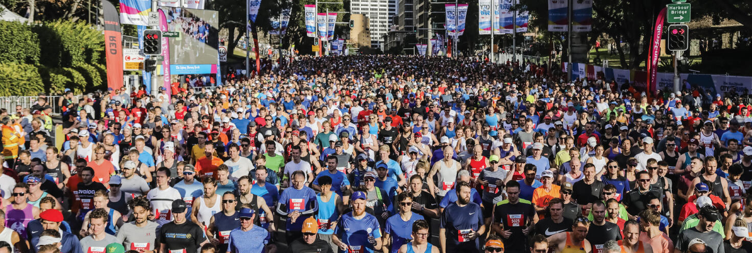
A sold-out group of 90,000 people will take to the streets in the 55th annual City2Surf 14km fun run between the city and Bondi Beach on Sunday 10 August. Participants will run from William St through The Kings Cross Tunnel, along Bayswater Rd, New South Head Rd, Old South Head Rd, Military Rd to Campbell Pde at Bondi Beach. Runners will be released in colour waves from 7:35am. The start line will close at 9:50am and the finish line will close at 1:50pm.
Transport
- With major road closures between the Sydney CBD and Bondi Beach from 6am, public transport is the best way to get to and from the event.
- Travel on public transport is covered for participants and volunteers.
- Early morning trains, light rail, buses and ferries will run to the city to get you to the start line. Express shuttle buses will also run from Bondi Beach (leaving from Bondi Rd near Sandridge St) to the city to get you to the start line.
- Red group: Use trains to Town Hall, St James or Museum stations, metro to Gadigal station (exit via Park St) or light rail and buses to QVB/Town Hall
- Green & Blue groups: Use trains to St James or Town Hall stations, metro to Martin Place, light rail to Town Hall or buses to Elizabeth St
- Pink & Yellow groups: Use trains to Museum or Town Hall stations, metro to Gadigal station (exit via Bathurst St) or light rail and buses to QVB/Town Hall
- Orange: If arriving before 8.30am - Use trains or metro to Martin Place, buses to Martin Place or Wynyard, and light rail services to Wynyard. If arriving after 8.30am head to Hyde Park North using trains to St James or Town Hall stations, metro to Martin Place, light rail to Town Hall or buses to Elizabeth St
- From Bondi Beach, frequent shuttle buses will run after the event from Bondi Beach to Bondi Junction to help you get home. Consider the 2.7km (35 minute) walk to Bondi Junction Station to connect with a train home.
- Keep in mind that buses between the city and the Eastern Suburbs will be affected with significant route diversions in place while major roads are closed for the event, so if you’re catching buses plan ahead and allow extra time.
- See our City2Surf 2025 bus network changes map (pdf 512KB) for all routes affected during the event.
Road closures and parking changes
- Key roads around the start area in Hyde Park in the Sydney CBD start closing from as early as 3.30am with major roads closing along the course from 6am from the city through to the Eastern Suburbs. Roads begin progressively reopening from 11.30am in the city, 12pm at Edgecliff, 1pm at Rose Bay, 2pm at Vaucluse & Dover Heights and 4pm at Bondi Beach and Bondi Junction.
- Heavy traffic is expected while roads are closed, so avoid unnecessary travel or expect delays and allow plenty of extra travel time on the roads.
- Special event clearway parking restrictions will again be enforced along the entire 14km course between 1am and midday in the city and 1am and 4pm through the Eastern Suburbs.
- Clearways are strict no-parking zones for all vehicle types, including those with local council parking permits or TfNSW mobility parking permits. Motorists and residents need to check signs carefully on the day and the night before as vehicles left in clearways will be towed and a fee applies.
- For detailed road closure information visit livetraffic.com.
Stay connected
Stay connected and get real-time updates on the event, transport services, traffic and road closures:
- Event updates: follow City2Surf on Facebook and @City2Surf on Instagram, or check the official City2Surf website for the latest event info.
- Transport updates: follow @TrainsInfo, @BusesInfo, @FerriesInfo and @SydneyMetro for real-time updates on transport services. Use the Trip Planner or the free Opal Travel App to plan your trip on event day.
- Road closures and traffic: follow @LiveTrafficSyd and Live Traffic NSW Facebook page for real-time traffic updates. Visit livetraffic.com for more real-time updates.
- Maps:
City2Surf 2025 event participants and volunteers are entitled to travel to and from the event on the following public transport services below. Just show your race bib, finishers medal or volunteer t-shirt to transport staff when boarding services.
- Sydney Trains & NSW TrainLink Intercity services * (non-booked services bounded by Bomaderry, Goulburn, Bathurst, Scone and Dungog stations)
- Sydney Metro services
- Regular route bus services and special event shuttle buses
- Sydney, Parramatta and Newcastle Light Rail services
- Sydney and Newcastle Ferries
Remember to keep your race bib, finishers medal or volunteer t-shirt safe for your return journey home or you'll need to use an Opal card or contactless payment method to travel on public transport. Your entitlement is valid on public transport services until 4am the next day.
* Note: an additional train station access fee applies for travel to or from Domestic and International Airport stations and is not covered by 2025 City2Surf travel entitlements
City2Surf 2025 Expo
The City2Surf Expo will be held at the Hordern Pavilion in Moore Park from 7 to 9 August. The Hordern Pavilion at Moore Park is easily accessible by light rail and buses. All 2025 City2Surf participants must collect their race bib prior to the race on Sunday 10 August.
Expo opening hours:
- Thursday 7 August from 12 midday to 7pm.
- Friday 8 August from 8am to 6:30pm.
- Saturday 9 August 7:30am to 4:30pm
Transport
- Light rail: L2 Randwick light rail services run between Circular Quay and Randwick via Central Station (Chalmers Street) and L3 Kingsford line services run between Circular Quay and Juniors Kingsford via Central Station (Chalmers Street). Catch L2 or L3 light rail services to Moore Park. The Moore Park stop is located along Anzac Parade, just south of the Hordern Pavilion.
- Trains: The closest train stations to Moore Park precinct are Central and Bondi Junction. From Central catch a light rail service from Chalmers Street to Moore Park. Alternatively, consider walking between Central and Moore Park via Devonshire Street and the Albert ‘Tibby’ Cotter Walkway. From Bondi Junction catch one of the many regular route buses from the Interchange to Oxford Street.
- Buses: A number of regular Sydney Buses services also stop along Anzac Parade near the precinct, including routes 339 and 374. From Bondi Junction Interchange, catch routes 333, 352 or 440 to Oxford Street or catch route 355 buses to Lang Road which is within short walking distance of the venue.
Parking
Parking is available onsite at the Entertainment Quarter Wilson Car park (casual parking rates apply). Car park is open 24 hours. Entry via Errol Flynn Boulevard from Lang Road.
Sydney Metro services are high-frequency, driverless trains running between Sydney’s north-west and south-west via the city.
The M1 Line operates turn up-and-go metro services in both directions between Tallawong, Chatswood and Sydenham.
Metro services run every 10 minutes from 4am then every 7 minutes from 6am to 4pm for the event.
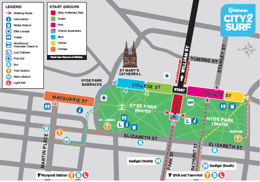
Getting to the start line:
- Red group: Use metro to Gadigal station (exit via Park St)
- Green & Blue groups: Use metro to Martin Place
- Pink & Yellow groups: Use metro to Gadigal station (exit via Bathurst St)
- Orange: If arriving before 8.30am - Use metro to Martin Place. If arriving after 8.30am - please head to Hyde Park North using metro to Martin Place
Getting home from the finish line:
- Catch event shuttle buses from Bondi Beach to Bondi Junction to connect with Sydney Trains services to Martin Place.
- From Martin Place it’s an easy underground walkway connection from Sydney Train services to Sydney Metro platforms for connecting services towards Tallawong or Sydenham.
- Metro services will run every 7 minutes from 6am to 4pm.
For Metro service disruption information, check travel alerts and trackwork or plan your trip using the Trip Planner.
Getting there
The closest stations to the start area at Hyde Park on College Street are St James, Museum, Town Hall and Martin Place.
Trains to the city run every 10 to 15 minutes, with services starting from as early as 4am depending on the line.
Additional services will leave Leppington at 5.53am and 6:23am, stopping all stations Lidcombe via Regents Park then Flemington, Strathfield, Burwood, Ashfield, Redfern then all stations to Circular Quay.
Getting to the start line:
- Red group: Use St James, Museum or Town Hall Stations, continue towards Park St.
- Blue and green groups: Use St James or Town Hall Stations, continue towards Hyde Park North.
- Pink and yellow groups: Use Museum or Town Hall Stations, continue towards Hyde Park South.
- Orange group: Use Martin Place Station, continue up Martin Place towards Macquarie St.
Getting home from the finish line:
After the race, shuttle buses will run back from Bondi Beach on Campbell Pde at Lamrock Ave and at Notts Ave to Bondi Junction Station where you can change for a train to continue your trip home.
At Bondi Junction trains will run every 5 minutes from 10am to 4pm on the T4 Eastern Suburbs & Illawarra Line between Bondi Junction, Central, Hurstville, Cronulla and Waterfall stations.
Once you're on the train, change at the following stations for easier access to your train line:
- For T1 North Shore Line, change at Town Hall.
- For T1 Western Line, change at Central.
- For T2 Inner West & South Line trains, change at Redfern.
- For T6 Bankstown Line, change at Lidcombe
- For T8 Airport Line trains, change at Wolli Creek.
- For T9 Northern Line, change at Town Hall.
- For intercity services, change at Central.
Trackwork
Planned trackwork is taking place on Sunday 10 August on the following lines and may affect how you travel to and from the event. Plan ahead using the Trip Planner.
- T2 Leppington & Inner West & Line: trains run to a changed timetable and stopping pattern between Leppington and the City, via Granville or Regents Park. Inner West trains run to the normal timetable.
- T3 Liverpool & Inner West Line: trains run to a changed timetable and stopping pattern between Leppington and the City, via Regents Park. Inner West trains run to the normal timetable.
- T6 Lidcombe & Bankstown Line: trains run to a changed timetable and reduced frequency, every 30 minutes.
- Blue Mountains Line: Buses replace trains between Lithgow and Mount Victoria. · Trains run between Mount Victoria and Central, some to a changed timetable. On Sunday until 5.20pm, trains run to a changed timetable between Katoomba and Central.
- Central Coast & Newcastle Line: some trains may run to a changed timetable due to trackwork between Strathfield and Central.
- South Coast Line: trains run to a changed timetable and stopping pattern. From 7.30am to 11.30am, at Helensburgh and Otford, all trains leave from platform 1. From 10am to 4pm, trains run to a changed timetable between South Coast Line stations and the City Circle. From 12pm to 4pm, at Otford and Helensburgh, all trains leave from platform 2.
Trackwork is carried out on an ongoing basis to maintain the safety, reliability, and efficiency of the Sydney Trains network. Check travel alerts and trackwork or use the Trip Planner.
Getting there
To the city: Plenty of bus services stop within short walking distance of the start area at Hyde Park. Additional early morning services to the city will run from as early as 4:15am on a number of routes from the North Shore, Northern Beaches, Eastern Suburbs, South West, Inner West and North West. Use the Trip Planner to plan your bus trip.
From Bondi: If you're travelling to the start area from Bondi, Route 382X buses will run every 5 minutes from Bondi Rd near Sandridge St to St James between 6am and 8:30am. Route 333 will run from Bondi Beach to Martin Place regularly from 6am to 8:30am.
Keep in mind road closures will be in place from as early as 3.30am in the city and 6am through the Eastern Suburbs so bus services will already be diverting from their regular routes while you’re on your way to the start line. See details of bus diversions below. See our TfNSW Interactive Road Closure and Clearway Map for more information on closures.
Make sure to plan ahead using the Trip Planner and give yourself plenty of extra travel time so you don’t miss your start time.
Getting home
Buses from Bondi Beach:
- To Bondi Junction: event shuttle buses will run from two bus stops on Campbell Pde, opposite Lamrock Ave and at Notts Ave, regularly from 9am until 4pm
- From the Finish Village use either Queen Elizabeth Dr or the eastern footpath of Campbell Pde to access either bus stop north of the roundabout.
- Accessibility: If you're travelling with a pram or have accessibility needs, catch the bus from the Lamrock Ave stop to avoid the stairs. Ensure prams are folded up to allow for faster boarding.
- Expect long queues from shuttle buses particularly from 11am when the larger numbers of participants arrive at the finish line. If you can, consider the walking up to the junction instead.
- From Bondi Junction you can change for a train from the station or another bus from the interchange to continue your trip home.
- To the city: Route 333 services to Circular Quay will run from a temporary stop on Sandridge St at Fletcher St (Stop ID: 2026109) from 6am until 4pm.
Remember, depending on when you reach the finish line roads along the course may still be closed and some bus services will continue to divert from their regular routes until 4pm. Plan ahead using the Trip Planner and check travel alerts for bus disruption information.
Bus diversions
Buses between the Sydney CBD and Eastern Suburbs will be diverting and using alternative routes and stops while road closures are in place for the event. Bus customers are encouraged to plan ahead, allow plenty of extra travel time on the day and be patient as delays are expected.
See our City2Surf 2025 bus network changes map (pdf 512KB) for all routes affected during the event.
Changes will also be in place at Bondi Junction Interchange with services using different stands - see our Bondi Junction Interchange map (pdf 173KB)
Services in the city will be affected between 3.30am and 12pm midday, services in the eastern suburbs will be affected between 6am and 4pm.
- Night Rides (N80, N81, N90, N91): from 3.15am until 12pm midday services will divert around road closures on William St and Park St. No stops will be missed.
- Route 311: from 3.30am until 3:30pm. Services towards Millers Point will divert around Hyde Park via the Cahill Expressway, Macquarie St, Bridge St and York St to re-join Kent St. Services towards Central will divert via King St, Elizabeth St to Cahill Expressway to Woolloomooloo. Stops will be missed on Crown St, William St, Park St, Town Hall QVB, Kent St and Bourke St.
- Route 324 (via Old South Head Rd):
- To the city: all early morning trips will run to Edgecliff only. The last trip from Watsons Bay will leave at 6.19am. Trips between 12pm and 1pm will start from Edgecliff Station, Stand N. Trips between 1pm and 2pm will start from New South Head Rd at Dover Rd (Stop ID 202955). The first trip to leave Watsons Bay as normal will run at 2:57pm.
- From the city: no trips will leave Walsh Bay until 12:02pm to Edgecliff only. First trip to run as normal to Watsons Bay leaves Walsh Bay at 1:32pm.
- Route 325 (via Vaucluse Rd):
- To city: no early morning trips will run. Trips towards Walsh Bay will start from Edgecliff Station, Stand N at 12:18pm and 12:48pm. Trips between 1.15pm and 2.15pm will start from New South Head Rd at Dover Rd (Stop ID 202955). The first trip to leave Watsons Bay as normal will run at 2:46pm.
- From the city: no trips will leave Walsh Bay until 12:16pm to Edgecliff only. Services from Walsh Bay to New South Head Rd at Dover Rd leave at 12:46pm and 1.17pm The first trip to run as normal from Walsh Bay to Watsons Bay leaves at 1:47pm.
- Route 326: services will not operate until 1pm. The first trip from Edgecliff to Bondi Junction will leave at 1.20pm. The first trip from Bondi Junction to Edgecliff will leave at 1.20pm.
- Route 327: services will not operate until around 2pm. The first trip from Edgecliff to Bondi Junction will leave at 1.50pm. The first trip from Bondi Junction to Edgecliff will leave at 1.55pm.
- Route 328: services will not run on this route until 1:08pm. Stops will be missed due to road closures
- Route 333: Due to the high volume of event shuttle buses route 333’s will start and end trips on Sandridge St instead of Campbell Pde at Bondi Beach. From 6am to 4pm services to Bondi Beach will run as normal to Bondi Rd, then end trips on Sandridge St at a temporary bus stop between Bondi Rd and Wilga St (Hunter Park) instead of Campbell Pde. Buses leaving Bondi will start trips from Sandridge St at Fletcher St (Stop ID 2026109) instead of Campbell Pde.
- Route 362: Services between Coogee and Rose Bay will not run throughout the day due to road closures. First trip from Rose Bay Wharf will leave at 4:02pm. First trip from Coogee will leave at 4:15pm.
- Route 379: From 6am to 4pm Route 379 services to and from Bondi will start and end trips at Warners Ave near Bondi Beach Public School.
- Route 380: From first service until 4pm Route 380 services will not operate. Catch a Route 386 or 387 service from Old South Head Rd at Dover Rd to Bondi Junction to connect with other bus services. For travel to Bondi Beach, join Route 333. For travel to Bondi Rd, join Route 381. Route 380 buses will resume running at 4.04pm from Watsons Bay and 4.05pm from Bondi Junction.
- Route 386: From 6am until around 2.30pm Route 386 services to Vaucluse will end at Dover Rd approaching New South Head Rd, Rose Bay. Services to Bondi Junction will start from Dover Rd near Carlisle St (Stop ID 202925). Stops in Vaucluse will be missed in both directions. First services to run as normal will leave from Vaucluse at 2.22pm and from Bondi Junction at 2.23pm.
- Route 387: From 6am until around 2.30pm Route 387 services will run between Rose Bay and Bondi Junction only, missing stops in Vaucluse. Buses will start and end trips at Old South Head Rd at Dover Rd in Rose Bay. First services to run as normal will leave from Vaucluse at 2.38pm and from Bondi Junction at 2.23pm.
- Route 389: From 3.30am until 12pm midday Route 389 services between Bondi and Pyrmont will be diverting via Darlinghurst Rd, Oxford St, Liverpool St and Elizabeth St missing stops on Park, William, Stanley and Bourke Streets. At Bondi Junction between 9am and 4pm, buses will pick up from Stand T at Grafton St (stop ID 202213) instead of Stand R. Buses arriving at Bondi Junction will drop off at Stand S (stop ID 202212)
- Route 441: From 3.30am until 12pm midday Route 441 services will start and end trips at QVB and will not continue to the NSW Art Gallery. Services to the city will end trips at York St Stand D (stop ID 200044). Services towards Birchgrove will start trips from QVB York St Stand B (Stop ID 200042).
- Route 461X: From 3.30am until 12pm midday Route 461 services towards the city will end trips at Elizabeth St at St James Station Stand C (stop ID 200057). Services towards Burwood will leave the city from Museum Station, Castlereagh St Stand F (Stop ID 200058). Stops on Park St will be missed.
- Route 504: From 3.30am until 12pm midday Route 504 services will not continue towards the Domain and will instead end trips at Town Hall, Park St, Stand H (Stop ID 2000249). Services towards Chiswick pick up from QVB, York St, Stand B (Stop ID 200042).
- Route 500N, 500X and 506: From 3:30am to 12pm Routes 500N, 500X and 506 to the city will end trips at Town Hall Station, Druitt St, Stand N (Stop ID 2000282) Services leaving the city will start trips from Town Hall Station, Druitt St, Stand L (Stop ID 2000423). Stops will be missed on Park St, William St, Riley St and St Marys Rd in both directions.
Other services will run to a regular weekend timetable. See bus timetables and maps or use the Trip Planner. For bus service disruption information, check travel alerts.
Sydney Ferries are a great way to get around the city but services can be popular and may reach capacity, especially on weekends so allow extra travel time and consider the alternative transport options.
The start line on College St at Hyde Park is around 10 minutes walk (1.5km) from Circular Quay or you can connect with train or light rail services to get within closer walking distance.
Additional F1 Manly ferries will leave Manly at 6:10am, arriving at Circular Quay at 6:32am and at 6:40am arriving at 7:02am. From the quay change for buses or light rail to get closer to the Hyde Park starting area.
For ferry service disruption information check travel alerts or use the Trip Planner.
L1 Dulwich Hill Line
L1 Dulwich Hill Line light rail services run between Central Station (Grand Concourse) and Dulwich Hill via Darling Harbour and the Inner West. Services run regularly from 5am to 1am daily. Plan your trip using the Trip Planner.
Change at Central to connect with L2 or L3 light rail services leaving from Chalmers St to get closer to the start line. Alternatively at Central, change for trains or metro services..
L2 Randwick and L3 Kingsford Lines
L2 Randwick light rail services run between Circular Quay and Randwick via Central Station (Chalmers Street) and L3 Kingsford line services run between Circular Quay and Juniors Kingsford via Central Station (Chalmers Street). Services run regularly from 5am to 1am daily, plan your trip using Trip Planner.
Catch L2 or L3 light rail services to Town Hall to get within walking distance of Hyde Park.
Additional services will run every 8 minutes between 6am until 10am for the event. Services will be busy so allow extra travel time or consider the alternative transport options including trains.
Getting to the start line:
- For Orange group – use L2/L3 services to Wynyard, or Trains/Metro to Martin Place.
- For Green & Blue groups – use L2/L3 services to Town Hall, Trains to St James or Town Hall stations, or Metro services to Martin Place
- For Pink & Yellow groups – use L2/L3 services to Town Hall, Trains to Museum or Town Hall stations, or Metro services to Gadigal Station (exit via Bathurst St).
- For Red group – use L2/L3 services to Town Hall, trains to Town Hall, St James or Museum stations or Metro services to Gadigal Station (north exit).
L4 Westmead and Carlingford Line
L4 Westmead and Carlingford Line light rail services run between Carlingford and Westmead via Parramatta CBD. Services run regularly from 5am to 1am daily. Plan your trip using the Trip Planner.
Alight at Parramatta Square and connect with a train service to Wynyard to get within walking distance of the start line. Alternatively, change at Central, Town Hall or Wynyard for an L2 or L3 Line service to Circular Quay to get within closer walking distance of the start line.
Passengers are reminded that trams can’t stop quickly or easily – so please stop, listen and look around for trams and use designated pedestrian crossings.
For maps and service frequencies see light rail service information. For light rail service disruption information, check travel alerts or plan your trip using the Trip Planner.
Key roads around the start area in Hyde Park in the Sydney CBD start closing from as early as 3.30am with major roads closing along the course from 6am. Heavy traffic is expected while roads are closed, so avoid unnecessary travel or expect delays and allow plenty of extra travel time on the roads.
Roads begin progressively reopening from 11.30am in the city, 12pm at Edgecliff, 1pm at Rose Bay, 2pm at Vaucluse & Dover Heights 4pm Bondi Junction and Bondi Beach.
Maps:
- Plan your trip and see our City2Surf 2025 interactive map for detailed road closures, clearways and nearest transport hubs to plan your movements on the day.
- Also see our PDF maps below
- City2Surf 2025 - overall road closure and clearway map (pdf 1.9MB)
- City2Surf 2025 - Sydney CBD to Double Bay road closures and clearways map (pdf 1.0MB)
- City2Surf 2025 - Double Bay to Dover Heights road closures and clearways map (pdf 572KB)
- City2Surf 2025 - Dover Heights to Bondi Junction closure and clearways map (pdf 763KB)
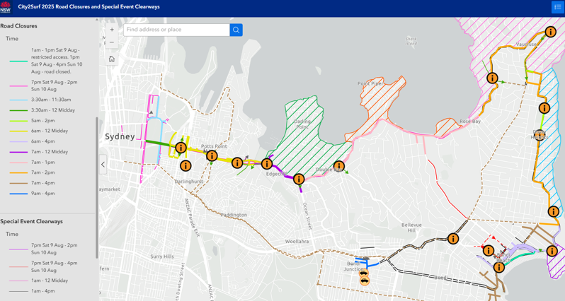
Key road closures
- Sydney CBD between 3.30am and 12pm: sections of College St, Macquarie St, Park St and St James Rd.
- Woolloomooloo to Edgecliff from 6am to 12pm midday: William St from Yurong St through to New South Head Rd at Ocean Ave. No access to the city via New South Head Rd west of Ocean St until 12pm, use alternative route via Oxford St.
- The Cross City Tunnel will be closed eastbound, access to Cross City Tunnel and Craigend St (westbound direction only) is maintained via McLachlan Ave at Rushcutters Bay.
- From the Eastern Distributor there is no access to William St or the Cross City Tunnel westbound.
- Double Bay to Rose Bay from 7am to 1pm: New South Head Rd from Ocean Ave to Dover Rd.
- Rose Bay to North Bondi from 7am to 2pm: New South Head Rd from Dover Rd to Old South Head Rd, Old South Head Rd from New South Head Rd to Oceanview Ave and Military Rd from Old South Head Rd to Blair St.
- Bondi Beach between 6am and 4pm: Campbell Pde from Hall St to Blair St from 6am. Campbell Pde from Dudley St to Hall St and Lamrock Ave from 6am.
- Note: Queen Elizabeth Dr restricted access from 1am - 1pm Sat 9 Aug then fully closed from 1pm Sat 9 Aug - 4pm Sun 10 Aug.
- Bondi Junction from 9am to 4pm: sections of Grafton St, Grosvenor St and Oxford St around Bondi Junction
Note: Queen Elizabeth Drive, Park Drive North and South at Bondi Beach will be closed from 1pm Saturday until 4pm Sunday and special event clearways will be in effect from 1am Sunday. This also applies to residents with Beach Parking Permits.
Local access & vehicle crossover points
Crossover points along the course will be maintained for local access until 7am or 7.10am, depending on the location. After these times there will be no vehicle access permitted while the run is underway until roads have safely reopened to traffic.
Vehicle course crossover points:
- Woolloomooloo/Darlinghurst: Crown St at William St two-way crossover open until 7:10am
- Darling Point: Exit only one-way from New Beach Rd to Neild Ave open until 7am
- Double Bay to Edgecliff: Exit only southbound from Ocean Ave to Ocean St open until 7:10am
- Double Bay to Bellevue Hill: Exit only southbound from Cross St to Bellevue Rd at New South Road until 7:10am
- Vaucluse/Rose Bay: Towns Rd / Vaucluse Rd at New South Head Rd two-way crossover open until 7:10am
- Vaucluse/Watsons Bay: Exit only one-way from Old South Head Rd at New South Head Rd until 7:10am
- North Bondi/Bondi Beach: Exit only one-way from Brighton Blvd at Campbell Pde and at Ramsgate Ave open until 7am. No entry after 6am.
Local access changes
- Bondi Rd will be heavily congested with hundreds of buses transporting thousands of participants between the beach and the junction. Local residents are strongly encouraged to avoid unnecessary travel on Bondi Rd. Residents north of Bondi Rd should use Old South Head Rd to enter or exit the area via Blair Street. Residents south of Bondi Rd should use Birrell St.
- Bondi Beach - Local access for properties at Bondi Beach will be maintained via one-way traffic only, entry via Curlewis, Gould and Hall Streets one-way. Properties between Lamrock Ave and Hall St exit onto Hall St only, no access to or from Lamrock Ave.
- Dover Heights – managed access for properties on Military Rd between Lancaster Rd and Blake St from 5am to 7am only.
- Cross City Tunnel westbound - Access to Cross City Tunnel and Craigend St (westbound direction only) is maintained via McLachlan Ave at Rushcutters Bay. The tunnel will be closed eastbound until 12pm midday.
For the latest traffic information visit Live Traffic NSW or download a real-time traffic app from the App Store or Google Play.
Parking
Key roads around the start line will close from as early as 3.30am and paid parking options are limited on Sunday mornings in the city so participants are encouraged to catch public transport. Travel on transport is covered by your event registration and there are plenty of frequent transport service options nearby.
If you have to drive, remember to allow extra time walking from your parking space to arrive around 30mins prior to your start time.
All available car park options can be found at the Wilson Parking, Secure Parking or City of Sydney - Parking.
Special event clearway
To ensure the event course is clear of vehicles special event clearway parking restriction will be in effect on both sides of the 14km course. Clearways will also be in effect on detour routes and streets surrounding the course.
Special event clearway parking restrictions will be in place along the entire 14km event course again this year.
Clearways are strict no-parking zones for all vehicle types, and also apply to local residents with parking permits and Mobility Scheme permit holders. Check signs carefully on the day and the night before as vehicles left in signposted clearways will be towed and a fee applies. If your vehicle is towed, you can search your vehicle registration at the Find My Car website to find its new location, or alternatively call 132 701 to speak to an operator.
Saturday 9 August (night before event) from 7pm:
- North Bondi, Medland-Bamford Ramp at Military Rd (both sides) until 2pm
- Rose Bay, O’Sullivan Rd from Latimer Rd to Old South Head Rd (eastern side/park side) until 4pm
Sunday 10 August (event day) from 1am:
- Sydney CBD to Rose Bay from 1am to 12pm: College St, Elizabeth St, Park St, Macquarie St and sections of Castlereagh St, Wentworth Ave and Hunter St. Both sides of William St/New South Head Rd from College St in the city through to Dover Rd in Rose Bay.
- Rose Bay to North Bondi from 1am until 4pm: both sides of New South Head Rd, Old South Head Rd, Military Rd and Campbell Pde.
- Bondi/North Bondi from 1am until 4pm: both sides of Bondi Rd from Old South Head Rd to Sandridge St, Old South Head Rd from Syd Einfeld Dr to Blair St.
- Bondi Beach from 1am until 4pm: both sides of Campbell Pde, Bondi Rd, Lamrock Ave and sections of Curlewis St, Gould St, Sandridge St and Wairoa Ave.
Check signs carefully on the day and the night before as vehicles left in signposted clearways will be towed and a fee applies. If your vehicle is towed it will be relocated to the nearest available legal parking space, call 132 701 to find its new location.
Other sections of the course do not have special event clearways, however, if you park on the event route before road closures are in place you will not be able to move your vehicle while the event is underway until roads reopen, unless permitted to do so by a Traffic Controller or NSW Police on-site.
Maps
Plan your trip and see our City2Surf 2025 interactive map for detailed road closures, clearways and nearest transport hubs to plan your movements on the day.
See our road closures and clearways PDF maps:
- City2Surf 2025 - overall road closure and clearway map (pdf 1.9MB)
- City2Surf 2025 - Sydney CBD to Double Bay road closures and clearways map (pdf 1.0MB)
- City2Surf 2025 - Double Bay to Dover Heights road closures and clearways map (pdf 572KB)
- City2Surf 2025 - Dover Heights to Bondi Junction closure and clearways map (pdf 763KB)
For more details on special event clearway locations and times, visit Live Traffic NSW.
Drop off for event start - Sydney CBD
The accessible drop off for the Start area is the western side of Phillip St between Martin Place and Hunter St, with access into Phillip St via King St only. Phillip St is closed southbound from Hunter St to create a one way northbound entry and exit system.
Pick up point at event finish - Bondi Beach
The accessible pickup location is on the southern side of Warners Ave between Wairoa Ave and the mid-block pedestrian crossing, behind Bondi Beach Public School. The approach route is via Ramsgate Ave eastbound, right into Wairoa Ave, right into Warners Ave. Participants are asked to be on site, ready to depart, before vehicles approach for pickup.
Accessible parking
Off-street secure parking with accessible spaces. For more information please visit the car park operators' websites: City of Sydney, Wilson Parking, Secure Parking, Domain Car Park.
Transport
Accessible trips are shown in the Trip Planner with the wheelchair icon. You can select "accessible services only" in the Options to ensure you only see accessible services. Only trip plans with accessible train platforms, ferry wharves and buses will be presented. See accessible travel or download a transport app (select the "Accessibility" filter).